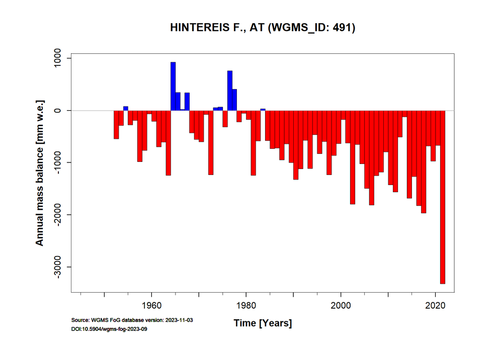
Mass Balance of Hintereisferner

Hintereisferner 28.08.2019
Hintereisferner is a valley glacier situated in the Eastern Alps of Austria (46.80° North / 10.77°E). This glacier has been classified as one of the key ‘reference glaciers’ by the World Glacier Monitoring Service because it has received continuous long-term observations dating back to the year 1952/53. The glacier descends from 3739 m a.s.l. to 2507 m a.s.l., with the tongue located in a northeast-orientated valley while the firn area faces north, east and south. The mean air temperature (1906-2005) measured at the climate station Vent (1890 m a.s.l) was 1.6 °C and the mean annual lapse rate is 0.57 °C/100 m. The glacier is not only monitored for its mass balance but has been the key glaciological study site serving as an Open Air Laboratory (OpAL) for the ACINN since the mid 19th Century.
The glacier mass balance monitoring is carried out by ACINN, subject to a contract with the Hydrographic Service, Government of Tyrol and additionally funded by the University of Innsbruck. Area changes are detected using airborne photogrammetry and, more recently via a decade of annual airborne LIDAR-campaigns. The mass balance studies are carried out by the ACINN applying the direct glaciological method and by the Institute for Geography applying the geodetic method. You can learn more about methods of measuring glaciological mass balance from the UNESCO Glossary of Glacier Mass Balance and Related Terms. Full winter balance measurements are performed annually at the beginning of May. Ice ablation is measured at >30 operational ablation stakes which are commonly read two to six times a year - depending on the respective location. Accumulation is measured in snow pits at the end of the hydrological year in late September, and by probing to measure the depth of the annual snow layer in the accumulation area.
The results of the mass balance studies are submitted annually to the World Glacier Monitoring Service.
Data access via WGMS database or the reference glacier site.
In autumn 2016 a permanent terrestrial laser scanner (TLS) was installed close to the summit „Im hinteren Eis“ (3.270 m a.s.l.) in cooperation with the Institute of Geography. More infromation here.
More information see Voordendag et al. (2021).
Two webcams that cover the whole glacier area were installed on the container of the TLS on May 25th:
Hintereisferner1 - View towards Weißkugel and Langtaufererspitze
Hintereisferner2 - View towards Hintere Hintereisspitze
In addition, a fully equipped automatic weather station (AWS) was installed close to the TLS position.

Weather station Im hinteren Eis, 06.07.2020.
Detailed information on the measurements in the form of annual reports is available at the ACINN on request.
Mass balance reports for Hintereisferner and Kesselwandferner (in German):
Bericht HEF-KWF1213
Bericht HEF-KWF1314
Bericht HEF-KWF1415
Bericht HEF-KWF1516
Bericht HEF-KWF1617
Bericht HEF-KWF1718
Bericht HEF-KWF1819
Bericht HEF-KWF1920
Bericht HEF-KWF2021
Bericht HEF-KWF2022
Bericht HEF-KWF2023
Bericht HEF-KWF2024
Bericht HEF-KWF2025
Project
Project Leader:
Rainer PRINZ
Members:
Lindsey NICHOLSON
Project Duration:
01/01/1952 to
Publications
Find a full list on Hintereisferner publications here.


