Chors, NW-Iran
directed by assoz. Prof. Dr. Sandra Heinsch, Dr. Gholam Shirzadeh, Dr. Ali Darvish-Zadeh and Dr. Walter Kuntner
Institut für Alte Geschichte und Altorientalistik, Universität Innsbruck, ICAR and RICHTO
I. Introduction
Starting from the reign of the Assyrian king Ashurnasirpal II (883-859 BCE) until the fall of the Neo-Assyrian Empire in 612 BCE the mountainous regions north and northeast of Assyria were constantly referred to in the Assyrian inscriptions by the toponym KURUrarṭu (Salvini 1967: 24). The etymology of this term, attested in phonetical variants since the time of Shalmaneser I (1274-1245 BCE), is unclear. The same is true also for its specific geographic and political meaning, in particular when compared to the other two toponyms KURḪabḫi (Russel 1984: 174-201) and especially KURNairi likewise used in the Assyrian geographical vocabulary to refer to these regions (Salvini 1998: 87-91). Although the terms KURḪabḫi and KURNairi were preferably used before the establishment of the kingdom of Urartu it is unclear whether there is a nexus between the Assyrian standardisation of naming and the state formation under Sarduri Lutipri sometime in the 30s of the 9th century BCE.
For even if the Urartian kings themselves used exclusively the toponym KURBiainili – of equally uncertain etymology (Salvini 1967: 15-16) – to refer to their ruled lands, the translation of this toponym into Assyrian is not consistent in the Urartian-Assyrian bilingual stelae. The stela of Kelišin dating to the period of the coregency of Išpuini and his son Menua in the last quarter of the 9th century BCE uses the Assyrian toponym KURNairi, whereas in the Movana stela of Rusa I. (735-714 BCE) the toponym KURUrarṭu is used (Mayer 2013).
Recently, the editors of the symposium Biainili-Urartu held at Munich in 2009 suggested to make use of this terminological situation to better describe the archaeological evidence and especially the dichotomy of the Iron Age material culture during the period of the kingdom of Urartu. The term Biainili is suggested by the authors to be restricted to refer specifically to the kingship and its material culture (Zimansky 1995). The term Urartu is understood on the other hand in its original meaning as a geographic term and used as a hypernym for the manifold Iron Age cultural traditions of this region, hence including also Biainili (Kroll et al. 2012: 1), and in the specific case of North-West Iran the so-called “Western Grey Ware Horizons” as well as “Late Buff Ware Horizon” later renamed by Dyson as Iron I, Iron II and Iron III on the basis of the stratigraphic sequence ascertained at Hasanlu (Young 1965. Dyson 1973). This concept is finally in accordance with Smiths and Thompsons idea of a “Southern Caucasian Political Tradition” which likewise emphasizes the common Late Bronze Age roots of the Iron Age cultural phenomena by stressing on the simultaneous appearance and spread of fortifications along with artificial irrigation systems in the territory of Georgia, Armenia, Azerbaijan, Eastern Turkey and North-West Iran as the most prominent common and unique characteristics of the Late Bronze to Iron III Ages (Smith and Thompson 2004. Smith 2012). Therein the kingdom of Biainili-Urartu is considered to represent the climax.

Fig. 1. Chors (Foto: S. Darvish-Zadeh)
II. The Regional Context of North-West Iran
The fertile plains along the coastal regions west of Lake Urmia were an integrated part of the Urartian kingdom since its earliest political formation in the last quarter of the 9th century BCE (Salvini 2009). An appraisal of Neo-Assyrian cuneiform inscriptions about this region by Fuchs (2004) has recently rekindled the suggestion proposed some time ago by Kroll (1984: 129) that this region might have even belonged to the native homeland of the Urartian dynasty (Kroll 2011). So far, there is, however, hardly any archaeological evidence to confirm this suggestion which, if proven to be true, would constitute a revolutionary aspect for our understanding of the genesis and the character of the kingdom of Biainili-Urartu especially when examined in comparison to the urban culture of Hasanlu IVc/b (Danti 2013: 16-23. Kroll 2013) generally related to the culture of Manna.
One major reason for this lack of information is that the archaeological investigation of Urartu has, since its beginning, been strongly oriented towards the Urartian cuneiform writings. Undeniable, such an approach is essential for the contextualisation of the archaeological sources as well as for the reconstruction of the political history, but at the same time it caused an adverse restriction on politico-military and economic aspects. In the context of the late 9th century BCE this approach can conclusively be seen for example in the investigations conducted at Qal´eh Ismail Aqa (Silenzi 1984), Qalatgah (Muscarella 1971) or Tashtepe (Salvini 1984. Muscarella 2012: 265-267). These sites are dated, moreover, on the basis of cuneiform inscriptions to the period of the co-regency of Išpuini and Menua or of the latter only and have therefore been always considered within the debate about the date of the destruction of Hasanlu IVB (Magee 2008).
The accentuation of the archaeological research on architectural surveys, that is on fortresses, as the most representative reflection of Urartian governance, can on the other hand be best demonstrated by the very important surveys conducted by the German Archaeological Institute under the leadership of Kleiss and Kroll. The surveys covered almost the entire territory of Iranian Azerbaijan. Although settlements were thoroughly surveyed during the reconnaissance their evidence has, so far, not be taken equivalently into account when assessing the character of the kingdom of Biainili-Urartu.
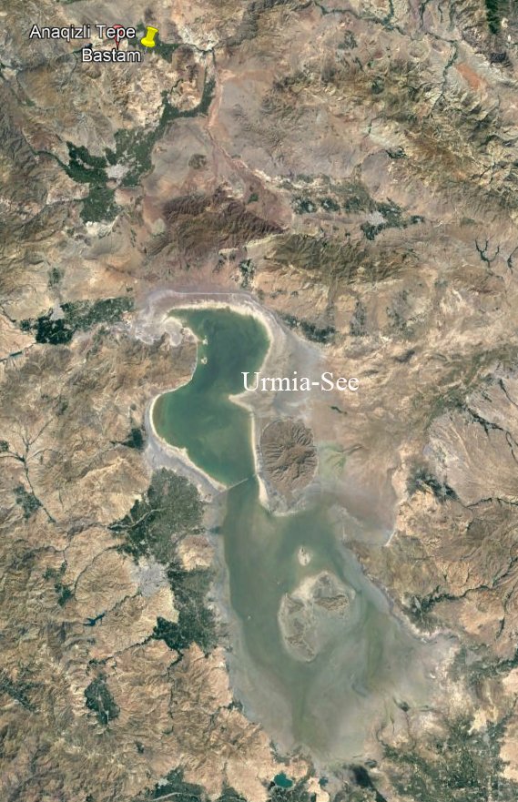
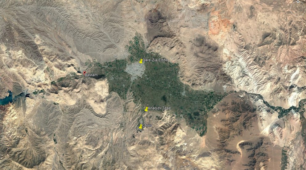
fig. 2. Quelle: google satellite
One major reason for this attitude derives again from a too literary reading of the Urartian inscriptions inasmuch as their content often led scholars to interpret the spread of Urartian fortresses concomitant with the mention of the destruction of several dozens of fortresses and villages as a general cultural break. Such, as to commonly define the beginning of the Iron III period by this event, with the effect, that the Iron II landscape has generally considered to cease to exist once captured by the victorious armies of Urartu. Yet, a careful reading of the Urartian inscriptions, especially when supplemented by the pictures emerging from the contemporary Assyrian inscriptions, clearly show that the landscape of Urartu was at all times complex and multi-layered comprising both hierarchically structured fortified as well as unfortified sites (Biscione 2009; 2012. Kroll 2005) as well as besides sedentary also nomadic communities (Lindsay & Greene 2013). In this context the so far unique unfortified estate of Haftavan III which probably served as an administrative centre is of greatest interest (Burney 1972: 137-142; 1973: 164-165). First, because it offers the seldom possibility to research more comprehensively the relationship between the administration of the kingdom of Biainili-Urartu and the agricultural population and secondly, because it constitutes so far the only settlement pre-dating the reign of Rusa II.
Despite the fact, namely, that over 80 Urartian sites are known today in Iranian Azerbaijan (Kleiss 2008) our knowledge on Urartian material culture still derive almost entirely from fortresses which were founded by Rusa II in the first half of the 7th century BCE or rather from their destruction horizon dating to around the middle of the 7th century BCE. For the region of Iranian Azerbaijan these are most notably Bastam (Kleiss 1979; 1988) and Agrab Tepe (Muscarella 1973).
This quite sobering observation, namely, the unequal awareness of Urartian material culture in the 9th and 8th compared to the 7th century BCE, was recently underscored by the Kroll et al. (2012: 1-38) to generally affect the state of archaeological research of Urartu.
In order to reach a more profound understanding of the kingdom of Biainili-Urartu it has to be started to comprehend also the complexity of interrelationship between Biainili and Urartu, this is between the fortresses as mirror of the expression of the political power and the rural settlements as the interlocutors of the common sections of societies (Stone 2012. Stone and Zimansky 2003. Zimansky 2012), preferably over the whole timespan of the culture phenomena referred here to as KURUrarṭu that is from the Late Bronze Age to Iron IV.
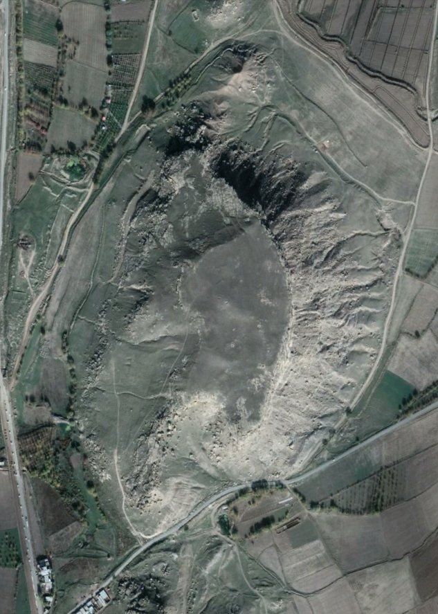
fig. 3. Anquizli Tepe (Quelle: google satellite)
III. The archaeological site of Chors
The village Chors (چورس) is located 40 km north of Khoy and 8 km southeast of Qara Zia’eddin on the southern fringe of the eponymous plain in Western Azerbaijan in the northern foothills of Safar Daghi Mountain. The plain is watered by the river Aghchay (arm. Deghmoud) which have its sources at the 70 km distant Aktaş Dağı Mountain (2715 m) on the border between Iran and Turkey. The archaeological Hill Anaqizli is situated 200 m north of the village of Chors on a natural rock plateau on an altitude of 1725 m above sea level (Pl. 1).
The region of Chors is commonly localised as one of the most likely places of the battle of Avarayr fought between Sassanid Persia and rebellious Armenians under Vartan Mamikonian in 451 CE. Likewise, in the Parthian period the area of Khoy acted as the gateway to the Parthian Empire marched through by the Roman army under Marc Antony during the Roman-Parthian War in 40-33 BCE (Balilan Asl and Jafari 2013).
The plain of Qara Zia Eddin has recently been emphasized by Dan (2010) as a paramount example for the research of the landscape polity of the kingdom of Biainili-Urartu (Olwig 1996, 2009, 2014). The prominent position of this plain is owed to the impressive archaeological investigations which have been realised by the German Archaeological Institute (DAI) under the leadership of Wolfram Kleiss in Iranian Azerbaijan, and most notably the excavations conducted in this context at Bastam, located at the eastern access into the plain just 10 km west of Chors from 1967 to 1978 (Kleiss 1979. Kleiss 1988).
Noteworthy is the reconnaissance of a dense network of fortresses built along and across the main valley and pass routes used by the Urartian kings to control and connect the fertile plains spread over the mountainous region delimited by the three Lakes of Van, Urmia and Sevan and aptly circumscribed by Zimansky (1995) as the ‘Urartian archipelago`.
The group of fortresses depending on the major centre of Bastam is composed according to the classification of Biscione (2012: 82-83) of the seven fortresses of Qal`eh Haidari, Turki Tepe, Ashagi Korul, Allahverdikand, Uzub Tepe, Duchgagi and Qal`eh Oghlu. The geographical distribution of these sites clearly indicates a mainly west-east oriented alignment which points to the existence of a basic route directly connecting Bastam with the capital Tushpa on the eastern shores of Lake Van across the Zagros range.
As recently stressed by Biscione (2012: 80) the unique size of Bastam clearly suggests that this fortress represented the main political center of the kingdom of Biainili-Urartu in NW-Iran during the 7th century BCE. It connected and controlled the access both to the capital Tushpa as well as the main North-South routes from Livar in the Marand plain and Seqendel in the Avar via the fortress of Verachram into to the Ararat plain to Erebuni, Karmir Blur, Armavir and further west to Altintepe in Anatolia.
This route was, however, under control well before the foundation of Bastam as indicated by the expansion of the kingdom of Biainili-Urartu versus the Caspian Sea already under Sarduri II as evidenced by the stone inscription of Seqendel (Salvini 1982) found next to the eponymous Iron II and Iron III fortresses (Kleiss & Kroll 1980) as well as vividly recorded in the rock inscriptions of king Argišti II. (714-680 BCE) at Shisheh north-east of Ahar, at Nasht-e ban and Razliq north-east of Sarab (Khanzaq et al. 2001).
It is therefore conceivable to assume that the site of Chors was located along one of the main routes of communication since the beginning of the kingdom of Biainili-Urartu, whose policy of whatever nature has for sure affected also the history of the settlement of Chors. This research aspect is in particular relevant in regard to fall of the kingdom of Biainili-Urartu in the 40is of the 7th century BCE. It is, namely, precisely this dramatic fate for whose investigation and dating the fortress of Bastam represents the key site, that accounts for the paramount importance of Chors for the research of the relation between Biainili on the one hand and Urartu on the other. The destruction horizon of Bastam allows, in fact, a unique archaeological ‘snapshot` of a period of occupation complemented by a markedly imperial environment covering a mere 20 to 30 years as a basis for comparative studies with the material from Chors in order to better assess the impact the foundation and fall of Bastam had had on the settlement occupation at Chors.

Fig. 4. The plateau (Foto: S. Darvish-Zadeh)
Team in 2016
Excavation directors
Dr. Gholam Shirzadeh
Dr. Ali Darvish-Zadeh
Dr. Walter Kuntner
Technical Support
Brigit Danthine MA
Findings
Ass.-Prof. Dr. Sandra Heinsch
Investigations in 2016
Investigations in 2016 included, in addition to a large-scale archaeological survey of the upper and lower plateau fortifications, as well as its immediate settlement area of Anaqizli Tepe and the surrounding area of one hectare, a geophysical prospection of the Anaqizli Tepe on the upper plateau, divided into Section A and Section B. While in Section A very well-preserved rectangular space chains can be seen, which seems to be fixed by a circular system, showed in Section B, due to the here already occurred robbery excavations in a much worse state. The evaluations of the ceramic material the Surveys speak of a settlement of 10./9. Century BC in central position of the plateau A, which spreads with increasing time over the entire area. The largest population took place between the 8th and 5th century BC. In addition to the official "state" ceramics, the so-called red polished pottery, takes a large share of the so-called "local" pottery. The settlement of the Anaqizli Tepe ends at the earliest in the 3rd century BC. Chr.
Excavations have already begun in trench RG3, on plateau A of the Anaqizli Tepe. The excavated spatial structures proved to be part of the already mentioned settlement with at least three building periods. The accompanying ceramics show a continuous ceramic sequence, supported by regional and supraregional comparisons, dating back to the 9th to the 5th century BC.
New results 2019