Keeping track of earthquakes
Most earthquakes are generated by the brittle deformation of rocks in the upper crust of the earth. Active plate tectonic processes move crustal segments slowly against each other. As soon as the stress at the weakest position exceeds the rock strength, a shear failure will occur, propagating with high velocity and causing a stress drop. Most energy released by this process spreads out as mechanical or seismic waves. If the energy is high enough, the waves may be felt as earthquakes at the surface.
Investigating seismic waves
The radiation pattern of seismic waves can be used to calculate the focal mechanism of an earthquake; that is the orientation of the focal planes and the relative movement of the crustal segments which moved during a tectonic earthquake. In his dissertation Franz Reiter calculates focal mechanisms and interprets them geologically: “It is important to get data from many seismological stations in order to be able to retrieve an unambiguous solution.” Modern seismographs are highly sensitive, so earthquakes can be analyzed which do not cause any victims or big damage at the earth surface. “The earthquake at Schwaz on the 19th of October, 2010 was felt by many people nearby. The waves could be detected by seismological stations from here to Spain,” Franz Reiter explains.
Gaining insight into the earth’s crust
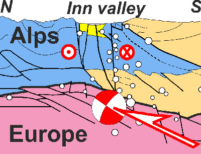
A tectonic model is necessary for the geological interpretation of earthquakes. This model shows the subsurface rock units and the position of potential failure zones. In many cases only surface geology may be used and extrapolated when building such a model. In the Inn valley case, radiation and reflexion patterns of artificial elastic waves complement these data. This method is called deep reflexion seismics. Some years ago, a deep seismic campaign was carried out, starting from Munich towards South and crossing the entire Alps. Prof. Hugo Ortner has interpreted the results of the seismic campaign in terms of geology. “Using reflexion seismics we are able to gain insight deep into the internal architecture of the Alps, similar to an ultrasonic image used in medicine”, Hugo Ortner explains. The subsurface continuation of the European plate can clearly be recognized in the reflexion pattern. From the Swabian Alb, this plate plunges towards the South and vanishes below the molasse basin, a huge depression filled with debris which was carried by rivers and glaciers from the Alps towards the northern foreland. Below the Inn valley at Brixlegg, the plate boundary between Europe and the Alpine nappes is in 8 km depth. This tectonic model also shows the main features of the Alpine orogeny in our area: The alpine nappe stack is pushed by the Adriatic plate towards northwest and thrust onto the European plate.
The Alps in motion
Earthquake zones like the Inn valley proof that the alpine orogeny has not ceased, yet. “The earthquakes below the Inn valley and the almost aseismic zone north of it show that the deformation moved from the mountain front into the orogen,” Franz Reiter says. “And we can prove that seismic events not only occur in the alpine nappes and the plate boundary to Europe but also within the European plate below.” The reason for this phenomenon is the reactivation of pre-existing fault planes in the European crust. These faults developed when extensional forces pulled at the former southern margin of the European Plate in the past. So far the interpretation of the seismic waves shows that earthquakes in the European plate indicate a northwest-southeast directed shortening. In the Alpine nappe stack evidence for active left-lateral strike-slip movements parallel to the Inn valley could be found.
Active tectonics – two different views
The interdisciplinary investigation of earthquakes leads to a better understanding of earthquake data. The geologic-tectonic information and position data from permanent GPS stations as a deterministic approach may be used to view at earthquakes from a completely different position. The earthquake zone in the Inn valley is considered as a zone with low deformation rates and high recurrence intervals of strong earthquakes. Such areas often show that the maximum earthquakes expected are estimated with a lower magnitude than those derived from earthquake geological studies – a hotly debated discrepancy.